After a year of record warm global temperatures caused by climate change and an El Niño weather pattern, “a weak La Niña” is expected to form ahead of the arrival of winter, , and could last through March of next year.
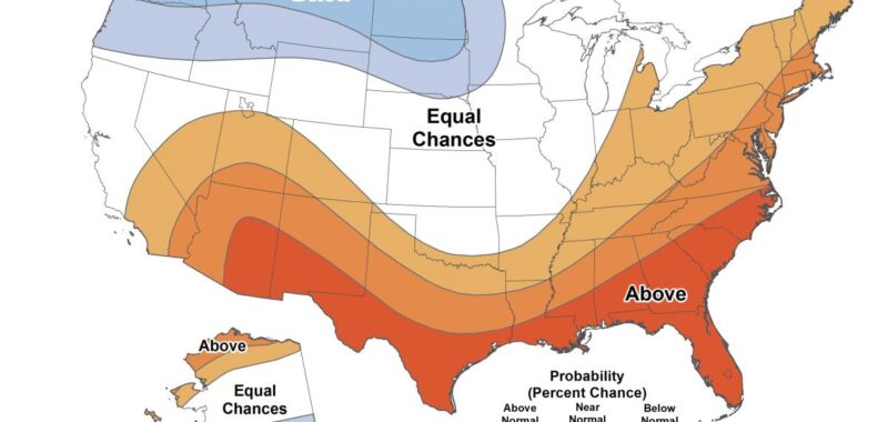
For much of the country, the relative weakness of the coming La Niña, which has a 60% chance of forming in November, will not result in winter temperatures above or below average, the National Oceanic and Atmospheric Association said in . But across the South, temperatures are expected to be above normal. The Pacific Northwest and the upper Great Plains states are forecast to experience colder-than-average temperatures.
“NOAA predicts wetter-than-average conditions for the entire northern tier of the continental U.S., particularly in the Pacific Northwest and the Great Lakes region, along with northern and western Alaska,” the agency said on its website. “Meanwhile, drier-than-average conditions are expected from the Four Corners region of the Southwest to the Southeast, Gulf Coast and lower mid-Atlantic states.”
While the arrival of La Niña could bring drought relief to the Ohio River Valley, other areas enduring dry conditions will not be so lucky.
“Unfortunately, after a brief period in the spring of 2024 with minimal drought conditions across the country, more than a quarter of the land mass in the continental U.S. is currently in at least a moderate drought,” Brad Pugh, operational drought lead with NOAA’s Climate Prediction Center, said in a release. “And the winter precipitation outlook does not bode well for widespread relief.”
The difference between El Niño and La Niña
The interplay between the two weather patterns typically translates into warmer temperatures during an El Niño event and colder weather during La Niña.
“During normal conditions in the Pacific ocean, blow west along the equator, taking warm water from South America towards Asia,” NOAA says . “To replace that warm water, cold water rises from the depths — a process called . El Niño and La Niña are two opposing climate patterns that break these normal conditions.”
But because forecasters are predicting a weaker and potentially short-lived La Niña, it will be “less likely to result in conventional winter impacts.”
Implications for the 2025 hurricane season
Because the jet stream pushes northward during La Niña events and weakens it over the Pacific, that pattern can result in warmer than normal temperatures across the Southern U.S. and can “lead to a more severe hurricane season,” NOAA said.
That’s not welcome news for portions of the country still struggling to recover from Hurricanes and .
“During La Niña events, atmospheric conditions tend to be more conducive to hurricane formation and intensification in the Atlantic Basin,” the Florida Oceanographic Society says . “The absence of strong wind shear allows hurricanes to develop and strengthen more easily, increasing the likelihood of landfall in Florida and the Gulf Coast.”
Climate change and the El Niño/La Niña cycle
While the fluctuation between El Niño and La Niña events can result in dramatic shifts in the weather, underlying that is the steady rise in global temperatures caused by greenhouse gas emissions.
“If you look at a chart of global average surface temperatures over time, you’ll see a steady rise due to increasing greenhouse gas concentrations in the atmosphere, but then you see ups and downs every few years,” Michael McPhaden, senior scientist at NOAA’s Pacific Marine Environmental Laboratory, told . “The ups are El Niño and the downs are La Niña.”